The Ancient Origins of New Year’s Celebrations – Ancient Origins

Ancient Origins Magazine
Evolution of Languages and Writings
Decoding Astronomy in Art and Architecture
Origin of the Zodiac: Cadair Idris and the Star Maps of Gwynedd
Viking Jewelry
Nexus Magazine
Armstreet
Inner Traditions
On January 1st of every year, many countries around the world celebrate the beginning of a new year. But there is nothing new about New Year’s. In fact, festivals and celebrations marking the beginning of a new calendar year have been around for millennia. While some festivities were simply a chance to drink and be merry, many other New Year celebrations were linked to agricultural or astronomical events.
In Egypt, for instance, the year began with the annual flooding of the Nile, which coincided with the rising of the star Sirius after a 70-day absence. This typically occurred in mid-July and was celebrated with a festival known as Wepet Renpet , which means “opening of the year.” The New Year was seen as a time of rebirth and rejuvenation, and it was honored with feasts and special religious rites.
The Phoenicians and Persians on the other hand began a new year with the spring equinox in March. The Persian New Year is called Nowruz (or Norooz) and is a 13-day spring festival which is believed to have originated as part of the Zoroastrian religion. Although official records of Nowruz did not appear until the 2nd century, most historians believe its celebration dates back at least as far as the 6th century BC. Nowruz traditions, such as bonfires and colored eggs, are still celebrated in Iran and other parts of the Middle East and Asia.


Colored eggs, samani (green sprouting wheat), and sweet pastry for Nowruz Holiday in Azerbaijan. ( Ali Safarov /Adobe Stock)
Jewish people celebrate the beginning of a new year in September or October, in observance of the lunisolar Hebrew calendar. Rosh Hashanah (Hebrew for “head of the year”) begins on the first day of Tishri, which is the first month of the calendar’s civil year but the seventh month of its religious year. The earliest reference to Rosh Hashanah in a rabbinic text comes from the Mishnah, a legal text from 200 AD, however the holiday is believed to be much older, perhaps originating in the sixth century BC.
Today, Rosh Hashanah is both a celebration for the upcoming year and a time to reflect on the past and one’s relationship with God. Jewish people often attend special services at their synagogues and celebrate with meals including a loaf of round challah, apples, and honey. The holiday is also linked to the blasts of the shofar (a trumpet made from a ram or kosher animal’s horn), which regularly sounds in synagogues at this time.


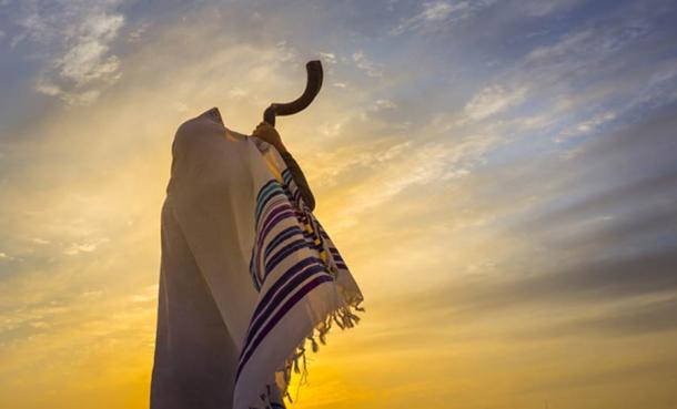
Blowing the shofar. ( John Theodor /Adobe Stock)
The first day of the Lunar New Year, meanwhile, occurs with the second new moon after the winter solstice. Popularly referred to as the Chinese New Year, millions of people across China, Korea, Vietnam, Japan, and other countries celebrate this event, which is also called the Spring Festival. The Chinese New Year is one of the oldest extant traditions in the world. This holiday has been traced back as far as three millennia ago, with origins in the Shang Dynasty. In its earliest days, this festival was linked to the sowing of spring seeds, but it eventually found ties to a fascinating legend.
One popular version of the myth discusses the annual exploits of a bloodthirsty creature called Nian —now the Chinese word for “year”. To protect themselves and frighten off the beast, villagers decided to decorate their homes with red ornaments, burn bamboo, and make loud noises. The tactic worked, and bright colors and lights are still present in China’s New Year’s festivities today.

Although the Chinese New Year is ancient, it is not the earliest recorded New Year’s festival – that record dates back to ancient Babylon some 4,000 years ago. It was deeply intertwined with religion and mythology. For the Babylonians of ancient Mesopotamia, the first new moon following the vernal equinox—the day in late March with an equal amount of sunlight and darkness—heralded the start of a new year and represented the rebirth of the natural world.

They marked the occasion with a massive religious festival called Akitu (derived from the Sumerian word for barley, which was cut in the spring) that involved a different ritual on each of its 11 days. During the Akitu, statues of the gods were paraded through the city streets and rituals were enacted to symbolize their victory over the forces of chaos. Through these rituals the Babylonians believed the world was symbolically cleansed and recreated by the gods in preparation for the new year and the return of spring.
In addition to the new year, Atiku celebrated the mythical victory of the Babylonian sky god Marduk over the evil sea goddess Tiamat and it served an important political purpose: it was during this time that a new king was crowned or that the current ruler’s divine mandate was renewed.

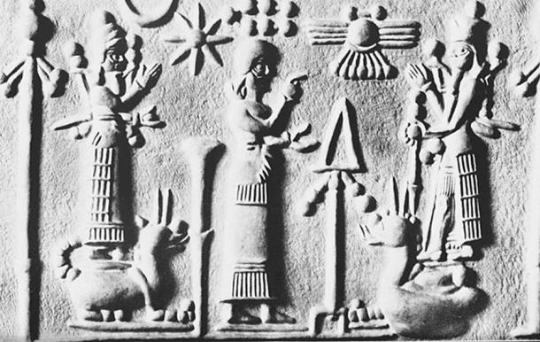
Late Assyrian seal. Worshipper between Nabu and Marduk, who is standing on his servant dragon Mušḫuššu. 8th century BC. ( The Commons )
One fascinating aspect of the Akitu involved a kind of ritual humiliation endured by the Babylonian king. This peculiar tradition saw the king brought before a statue of the god Marduk, stripped of his royal regalia, slapped, and then dragged by his ears in the hope of making him cry. If royal tears were shed, it was seen as a sign that Marduk was satisfied and had symbolically extended the king’s rule.

The Roman New Year also originally corresponded with the vernal equinox. The early Roman calendar consisted of 10 months and 304 days, with each new year beginning at the vernal equinox. According to tradition, the calendar was created by Romulus, the founder of Rome, in the eighth century BC.
However, over the centuries, the calendar fell out of sync with the sun, and in 46 BC the emperor Julius Caesar decided to solve the problem by consulting with the most prominent astronomers and mathematicians of his time. He introduced the Julian calendar, a solar-based calendar which closely resembles the more modern Gregorian calendar that most countries around the world use today.
As part of his reform, Caesar instituted January 1 as the first day of the year, partly to honor the month’s namesake: Janus, the Roman god of change and beginnings, whose two faces allowed him to look back into the past and forward into the future. This idea became tied to the concept of transition from one year to the next.
Romans would celebrate January 1st by offering sacrifices to Janus in the hope of gaining good fortune for the New Year, decorating their homes with laurel branches, and attending raucous parties. This day was seen as setting the stage for the next 12 months, and it was common for friends and neighbors to make a positive start to the year by exchanging well wishes and gifts of figs and honey with one another.

In Medieval Europe, however, the celebrations accompanying the New Year were considered pagan and unchristian-like, and in 567 AD the Council of Tours abolished January 1st as the beginning of the year, replacing it with days carrying more religious significance, such as December 25th or March 25th, the Feast of the Annunciation, also called “Lady Day”.
The Feast of the Annunciation is the day to celebrate the event in the Bible when Archangel Gabriel appeared to Mary and offered her the opportunity of being mother to  Jesus, the Son of God. Mary checked some of the conditions and learned that her virginity would remain intact, so she accepted the holy mission. She instantly became pregnant with the holy child, a decision that would lead to her becoming the most famous woman on Earth.

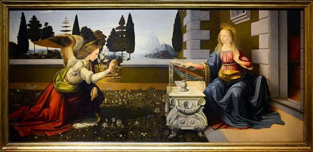
The Annunciation by Leonardo da Vinci. ( CC BY-SA 4.0 )
March 25 was first adopted as the Feast of the Annunciation around the 4th or 5th centuries. According to the Christian  Church, the feast is a celebration of when God entered the human world as his only son, Jesus, in order to save humanity. It’s also a celebration of Mary’s free acceptance of the role of mother to the holy child, signifying humanity’s acceptance of God’s act. The Son of God was to live as a human, and so he would come into the world through the same means as a human. Thus, the date of the Annunciation was set 9 months (a standard human pregnancy term) before the day of Jesus’ birth.
The date of January 1st was also given Christian significance and became known as the Feast of the Circumcision, considered to be the eighth day of Christ’s life counting from December 25th, and following the Jewish tradition of circumcision eight days after birth on which the child is formally given his or her name. However, the date of December 25th for the birth of Jesus is debatable .
In 1582, after reform of the Gregorian calendar, Pope Gregory XIII re-established January 1st as New Year’s Day. Although most Catholic countries adopted the Gregorian calendar almost immediately, it was only gradually adopted among Protestant countries. Countries belonging to the Eastern Orthodox Church did not readily adopt the Gregorian calendar either.
The British, for example, did not adopt the reformed calendar until 1752. Until then, the British Empire, and their American colonies, still celebrated the New Year in March!
Top Image: A firework show at the Temple of Dawn in Thailand . Every country and culture has its own New Year’s tradition. Source: nirutft / Adobe Stock
By Joanna Gillan
Updated on December 31, 2021.
Joanna Gillan is a Co-Owner, Editor and Writer of Ancient Origins. 
Joanna completed a Bachelor of Science (Psychology) degree in Australia and published research in the field of Educational Psychology. She has a rich and varied career, ranging from teaching… Read More
  native:  thank you for your transmission and deffinition!
  so, is a line from perhelion,january 4 (sirius star)through the sun and toward aphelion,july 5(star vega in lyra) what is called the ‘rulers line’ and the direction of the milky way galaxy center is in the direction of the extension of that line through vega in lyra?  how is the direction of galactic rotation in relation to the rulers line determined?
 
Quote:
“As part of his reform, Caesar instituted January 1 as the first day of the year, partly to honour the month’s namesake: Janus, the Roman god of change and beginnings, whose two faces allowed him to look back into the past and forward into the future.  This idea became tied to the concept of transition from one year to the next”.
The ritual of Janus is connected to some very important cosmological issue, namely the Story of Creation which is closely connected to the Milky Way and the creation of this.
As our Solar System is an integrated part of the Milky Way rotation and formation, it is of course very important to know of the Milky Way central direction. Many cultures have their celestial markings of this direction.
When one locates the Sirius star and make a line over the celestial pole area and to the star Vega i Lyra, one gets the direction to the Milky Way center from where our Solar System is created.
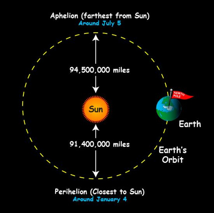
This “ruler line” of course excist all the time, but is epecially connected to the month of January when the Earth is closest to the Sun and in July it is farthest away from the Sun. These orbital positions mirrors the direction to and away from the Milky Way center and thus it ritually and mythologically  speaks of “the past from where we origin and to the future where we are going”.
See this illustration –   http://en.es-static.us/upl/2014/01/aphelion-perihelion-earth.jpg – This ritual is connected to the Star of Bethlehem (Sirius) and the 3 wise men (Orion Belt stars) and takes specifically place about 2-6 january, but it is also connected to the Midvinter Solstice in a longer feastive period.
Best Wishes and a Happy New Year
it would seem the more i learn that all religions n holidays we still celibrate r based on pagan  rituals n for the essenc of them to have survived this long even through all the changes n oppostion they have faced must mean that at there basic level they r significant to r humanity in some vital way that we can not currently understand
Live laugh love
Ancient Origins Store
Anatolia Turkey
IRAN Expedition
SUDAN Expedition
All Expeditions
Ancient Origins DNA
Natural History
Ancient Origins Magazine
Historic Mysteries
 
 
Ancient Origins has been quoted by:
Ancient Origins Quotations
At Ancient Origins, we believe that one of the most important fields of knowledge we can pursue as human beings is our beginnings. And while some people may seem content with the story as it stands, our view is that there exist countless mysteries, scientific anomalies and surprising artifacts that have yet to be discovered and explained.
The goal of Ancient Origins is to highlight recent archaeological discoveries, peer-reviewed academic research and evidence, as well as offering alternative viewpoints and explanations of science, archaeology, mythology, religion and history around the globe.
We’re the only Pop Archaeology site combining scientific research with out-of-the-box perspectives.
By bringing together top experts and authors, this archaeology website explores lost civilizations, examines sacred writings, tours ancient places, investigates ancient discoveries and questions mysterious happenings. Our open community is dedicated to digging into the origins of our species on planet earth, and question wherever the discoveries might take us. We seek to retell the story of our beginnings. 
Ancient Origins © 2013 – 2022
Disclaimer – Terms of PublicationPrivacy Policy & CookiesAdvertising Policy – Submissions We Give BackContact us

source

9th Century BC Moat to Protect Phoenician Settlement Excavated in Spain – Ancient Origins

Ancient Origins Magazine
Evolution of Languages and Writings
Decoding Astronomy in Art and Architecture
Origin of the Zodiac: Cadair Idris and the Star Maps of Gwynedd
Viking Jewelry
Nexus Magazine
Armstreet
Inner Traditions
Archaeologists working at a in the Alicante province of Spain have just discovered a large moat. This emphasizes the defensive actions taken by the settlers against the hostility they faced when they lived on the Iberian coast between the 8th and 9th century BC.
The moat is one of the defensive features of the Phoenician settlement at the archaeological site of Cabezo Pequeño del Estaño (also known as Cabeço de l’Estany), located in the coastal town of Guardamar del Segura. A University of Alicante press release reports that the moat is three meters (9.84 ft.) deep and over eight meters (26.25 ft.) wide at the top. It was dug by hand and the chisel marks made by the ancient workers can still be seen in the rocky substratum even today.
The archaeologists received clues to the moat’s existence by examining aerial photography , which suggested it was located on a hill parallel to the settlement’s walls. The moat itself was covered in an excess of soil, not only due to the passage of time, but possibly also because of ancient earthquakes and illegal quarrying at the site in 1988. Nonetheless, one of the archaeologists and site directors, Fernando Prados of the Instituto Universitario de Investigación en Arqueología y Patrimonio Histórico (INAPH)  of the University of Alicante, has called the moat “enormous and intact.”

Photo of the recently discovered Phoenician moat. (Universidad de Alicante)
Photo of the recently discovered Phoenician moat. ( Universidad de Alicante )
Archaeologists said that along with the one in the Castle of Doña Blanca, in Cadiz, “the latest discovery is the only Phoenician moat still preserved in the western Mediterranean area from its time,” according to RUVID. The University of Alicante press release also states that “As with the spectacular wall of this site, the closest known parallels to the Phoenician moat are found in the Middle East, in Phoenician cities like Tell Dor or Beirut (now the capital of Lebanon).”
This is just the latest discovery suggesting the importance of the settlement at Cabezo Pequeño del Estaño in leading Phoenician colonial policy between the 9th and 8th centuries BC. The project website shows that the INAH has been excavating the site in collaboration with the Archaeological Museum of Guardamar del Segura since 2013.

The excavators have made some remarkable finds over the years, resulting in the conclusion that this was a major site for metallurgy and trade . The researchers also see the defensive wall and moat as clear signs that the Phoenician inhabitants of the settlement on the mouth of the river confronted attack from locals.
Part of the defensive wall at the Phoenician settlement. (Ripoll531/CC BY SA 4.0)
Part of the defensive wall at the Phoenician settlement. (Ripoll531/ CC BY SA 4.0 )
The project website states that the team has focused on three main areas of the well-planned site: the citadel, the western wall’s vaulted chamber, and the housing area. The oldest sections of the Phoenician settlement have been dated to around 780 BC. ABC reported in 2019 that the Phoenicians weren’t used to the seismic activity they faced in the area, and unwittingly they built tall walls that they had to repeatedly repair. It seems the Phoenician settlement was abandoned around 700 BC, possibly following a particularly bad earthquake.
Image showing the wall (muralla), moat (foso), and citadel (ciudadela) at Cabezo Pequeño del Estaño. (Universidad de Alicante)
Image showing the wall (muralla), moat (foso), and citadel (ciudadela) at Cabezo Pequeño del Estaño. (Universidad de Alicante )
Some of the most interesting finds made during previous excavations were in the large, circular metallurgical workshop, complete with a workbench, furnaces, forges, smelting tools and galena – a mineral from which the Phoenician metalworkers extracted silver.
Fernando Prados said that the metallurgy workshop was in use between approximately 700 and 650 BC, “a time that corresponds to the second phase of life of this town founded around 780 BC and partially destroyed by an earthquake that occurred around 730.” The researchers discovered the age of the workshop by using radiocarbon dating on seeds found around that location.
Pottery discovered during previous excavations at the ancient Phoenician settlement at Cabezo Pequeño del Estaño. (Universidad de Alicante)
Pottery discovered during previous excavations at the ancient Phoenician settlement at Cabezo Pequeño del Estaño. ( Universidad de Alicante )
The silver crafting workshop also provided clues on the connections which the Phoenicians had with other areas because the minerals used in their work “arrived by boat from the mountains of Almeria and Murcia,” according to Prado. The researchers found that the silver ingots produced at Cabezo Pequeño del Estaño were exported all over the Mediterranean to the Middle East, providing them with more information on the scale of the Phoenician commercial circuit in the Hispanic southeast at the time.

Top Image: Aerial view of the Phoenician settlement at Cabezo Pequeño del Estaño in Alicante, Spain. Inset; Examples of Phoenician silver found at other sites. Source: Fernando Prados /Public Domain /Public Domain
By Alicia McDermott
Alicia McDermott holds degrees in Anthropology, Psychology, and International Development Studies and has worked in various fields such as education, anthropology, and tourism. Ever since she was a child Alicia has had a passion for writing and she has written… Read More
Ancient Origins Store
Anatolia Turkey
IRAN Expedition
SUDAN Expedition
All Expeditions
Ancient Origins DNA
Natural History
Ancient Origins Magazine
Historic Mysteries
 
 
Ancient Origins has been quoted by:
Ancient Origins Quotations
At Ancient Origins, we believe that one of the most important fields of knowledge we can pursue as human beings is our beginnings. And while some people may seem content with the story as it stands, our view is that there exist countless mysteries, scientific anomalies and surprising artifacts that have yet to be discovered and explained.
The goal of Ancient Origins is to highlight recent archaeological discoveries, peer-reviewed academic research and evidence, as well as offering alternative viewpoints and explanations of science, archaeology, mythology, religion and history around the globe.
We’re the only Pop Archaeology site combining scientific research with out-of-the-box perspectives.
By bringing together top experts and authors, this archaeology website explores lost civilizations, examines sacred writings, tours ancient places, investigates ancient discoveries and questions mysterious happenings. Our open community is dedicated to digging into the origins of our species on planet earth, and question wherever the discoveries might take us. We seek to retell the story of our beginnings. 
Ancient Origins © 2013 – 2022
Disclaimer – Terms of PublicationPrivacy Policy & CookiesAdvertising Policy – Submissions We Give BackContact us

source

Byblos – UNESCO.org

The World Heritage Centre is at the forefront of the international community’s efforts to protect and preserve.
World Heritage partnerships for conservation
Ensuring that World Heritage sites sustain their outstanding universal value is an increasingly challenging mission in today’s complex world, where sites are vulnerable to the effects of uncontrolled urban development, unsustainable tourism practices, neglect, natural calamities, pollution, political instability, and conflict.
Our Partners Donate
Take advantage of the search to browse through the World Heritage Centre information.
The ruins of many successive civilizations are found at Byblos, one of the oldest Phoenician cities. Inhabited since Neolithic times, it has been closely linked to the legends and history of the Mediterranean region for thousands of years. Byblos is also directly associated with the history and diffusion of the Phoenician alphabet.
Description is available under license CC-BY-SA IGO 3.0
On trouve à Byblos les ruines successives d’une des plus anciennes cités du Liban, habitée dès le néolithique et étroitement liée à la légende et à l’histoire du bassin méditerranéen pendant plusieurs millénaires. Byblos est directement associée à l’histoire de la diffusion de l’alphabet phénicien.
Description is available under license CC-BY-SA IGO 3.0
نجد في جبيل الآثار المُتتاليّة لإحدى أقدم المدن في لبنان التي سكنتها الشعوب منذ العصر النيوليتي والتي تُعتبر جزءًا لا يتجزّأ من أسطورة حوض البحر الأبيض المتوسّط ومن تاريخه على مرّ ألوف السّنين. كما ترتبط جبيل ارتباطًا وثيقًا بتاريخ انتشار الأبجديّة الفينيقيّة.
source: UNESCO/ERI
Description is available under license CC-BY-SA IGO 3.0
比布鲁斯是黎巴嫩最古老的城市之一,在那里发现了许多连续的文明废墟。它从新石器时代就开始有人居住,与数千年来地中海地区的传奇和历史紧密联系在一起。同时比布鲁斯也与腓尼基字母表的发展传播息息相关。
source: UNESCO/ERI
Description is available under license CC-BY-SA IGO 3.0
В Библе, одном из древнейших финикийских городов, обнаружены следы многих сменявших друг друга цивилизаций. Населенный уже в период неолита, он был тесно связан с легендами и историей Средиземноморья в течение тысячелетий. Библ также непосредственно связан с историей и распространением финикийского алфавита.
source: UNESCO/ERI
Description is available under license CC-BY-SA IGO 3.0
En Biblos se encuentran las ruinas de las sucesivas épocas de una de las más antiguas ciudades del Líbano, que fue habitada desde el Neolítico y estuvo estrechamente vinculada durante milenios a la leyenda y la historia de la cuenca del Mediterráneo. Biblos también está directamente asociada a la historia de la difusión del alfabeto fenicio.
source: UNESCO/ERI
Description is available under license CC-BY-SA IGO 3.0
source: NFUAJ
De kustplaats Byblos ligt op een klif van zandsteen zo’n 40 kilometer ten noorden van Beiroet. In de stad zijn de ruïnes van vele opeenvolgende beschavingen te vinden. Het is een van de oudste Fenicische steden. De stad wordt al bewoond sinds de neolithische tijd en is al duizenden jaren nauw verbonden met de legendes en geschiedenis van het Middellandse Zeegebied. De evolutie van de stad is duidelijk zichtbaar in de overblijfselen verspreid over het terrein, waaronder de middeleeuwse stad ‘intra muros’ en de antieke woningen. Byblos wordt ook direct in verband gebracht met de geschiedenis en de verspreiding van het Fenicische alfabet.
Source: unesco.nl
Brief synthesis
The coastal town of Byblos is located on a cliff of sandstone 40 km North of Beirut. Continuously inhabited since Neolithic times, Byblos bears outstanding witness to the beginnings of the Phoenician civilization. The evolution of the town is evident in the structures that are scattered around the site, dating from the different periods, including the medieval town intra-muros, and antique dwellings. Byblos is a testimony to a history of uninterrupted construction from the first settlement by a community of fishermen dating back 8000 years, through the first town buildings, the monumental temples of the Bronze Age, to the Persian fortifications, the Roman road, Byzantine churches, the Crusade citadel and the Medieval and Ottoman town. Byblos is also directly associated with the history and diffusion of the Phoenician alphabet. The origin of our contemporary alphabet was discovered in Byblos with the most ancient Phoenician inscription carved on the sarcophagus of Ahiram.
Criterion (iii): Byblos bears an exceptional testimony to the beginnings of Phoenician civilization.
Criterion (iv): Since the Bronze Age, Byblos provides one of the primary examples of urban organization in the Mediterranean world.
Criterion (vi): Byblos is directly and tangibly associated with the history of the diffusion of the Phoenician alphabet (on which humanity is still largely dependent today), with the inscriptions of Ahiram, Yehimilk, Elibaal and Shaphatbaal.
Integrity 
The inscribed property comprises Phoenician and Roman elements whilst the large protected zone requested by the World Heritage Committee covers the medieval town within the walls and the sector of the necropolis, and consequently many features are located beyond the boundaries. The ancient town of Byblos intra-muros possesses all the elements characterising a medieval town (wall, cathedral, castle and donjon), later modified as an Ottoman-type town (souqs, khans, mosque, houses).  The strong urban pressure that threatens this Ottoman town has for the most part been contained thanks to national and international listing of this part of the town, but new developments around the port remain a threat. The archaeological sites are rendered very vulnerable through lack of consolidation work following excavations and many monuments are awaiting repair to avoid the risk of collapse, which has been the case of a wall located nearby the rampart.
Authenticity
The authenticity of the archaeological elements is very vulnerable because the climatic conditions cause the erosion of some parts, reducing comprehension of what they represented.  This phenomenon is a source for concern and more particularly as regards the mosaics.
Protection and management requirements
The site is protected by the Lebanese Antiquities Law 133/1937 and law NO 166 of 1933. The town plan and of the listed zone is being implemented. The town intra-muros is inscribed on the national list of Historic Monuments. The conservation and management of the site of Byblos are ensured by the Directorate General of Antiquities (DGA). Targeted conservation projects are underway within the property. All restoration and other permits in the intra-muros zone must be submitted for approval to the DGA. As concerns construction permits, the same laws mentioned above are applicable not only within the site but also throughout the whole region of Byblos. The DGA retains the right to modify any construction project, depending upon the buried archaeological discovered during sounding operations, before granting a permit.  Agreement with the Municipality and the local police force is required in order to counter, if need be, any illegal action on the part of the owner. A protection and enhancement plan for the site is being prepared to ensure a better presentation of these unique ruins and to develop a new protection system for the site while respecting international charters. Cooperation with specialists in the restoration of historic monuments is primordial. The plan should coordinate all those specializations involved in the property and also treat the subject of underwater remains.
by year
Committee sessions Statutory Documents Committee decisions More sessions… 45th session (postponed) 44th session (2021) 15th Extraordinary session (2021) 43rd session (2019) 42nd session (2018)
General Assembly 23rd GA UNESCO Paris (2021) 22nd GA UNESCO Paris (2019)
About World Heritage The Convention Convention Text Policy Compendium Operational Guidelines The Emblem The States Parties The Advisory Bodies The Centre Employment & Internships Who’s Who
The List World Heritage List World Heritage in Danger New Inscriptions Criteria for Selection Tentative Lists World Heritage List Nominations
Reporting & Monitoring State of Conservation (SOC) Periodic Reporting Questionnaires 2018-2024 Questionnaires 2008-2015 Reactive Monitoring Africa Arab States Asia & Pacific Latin America and the Caribbean Europe and North America
Partnerships Become a Partner What Partners Do Our Partners
Activities All our activities Volunteer Group Tools
Publications World Heritage Review Series Resource Manuals World Heritage wall map More publications …
Funding World Heritage Fund International Assistance
More Contacts Site Map Become a member Donate Now!
© UNESCO World Heritage Centre 1992-2022

source

Nora, the Ancient Sardinian Trading Town that Everyone Wanted – Ancient Origins

Ancient Origins Magazine
Evolution of Languages and Writings
Decoding Astronomy in Art and Architecture
Origin of the Zodiac: Cadair Idris and the Star Maps of Gwynedd
Viking Jewelry
Nexus Magazine
Armstreet
Inner Traditions
Nora is arguably the first town ever built on the island of Sardinia, one of the largest islands in the Mediterranean Sea. Their rich and remarkable history includes occupation by Phoenicians, Carthaginians, Romans, Vandals, and Byzantines. For many years the island was an important and prosperous trading hub. Today the town is an open-air archaeology park.
The first known inhabitants of the island were the Nuragic people , renowned for their megaliths. According to Greek sources, the Phoenicians colonized the area sometime in the 8th century BC and founded the first town, then named Norax. Many suppose that the Phoenicians came from the Spanish colonies and used the town to control the trade in the region. The Phoenicians had a good relationship with the inhabitants of the mountainous interior.
Sometime after the Fall of Tyre in the mid-6th century BC, the Carthaginians became the dominant power among the Phoenician settlement and took over Nora, making it a part of their empire.  From Nora, they expanded their control of Sardinia into the interior, under the generals Asdrubale and Amilcare. By 509 BC they dominated the island. Based on the tombs excavated in its vicinity, Nora prospered because of its port and the trade in metal ore.

The Romans defeated the Carthaginians in the 3rd century BC and occupied Nora. They built over the Carthaginian town of which very little now remains, although some Carthaginian remains such as the Tophet (religious sanctuary) that was exposed during a storm have come to light. It is believed that the Roman forum was built on top of the Carthaginian plaza.
The Nora bay and beach, the medieval Sant'Efisio church near the shore and mountains in the background (pilat666 / Adobe Stock)
The Nora bay and beach, the medieval Sant’Efisio church near the shore and mountains in the background ( pilat666 / Adobe Stock)
The Romans initially made Nora their provincial capital but later transferred it to Karlais (Caligari). The town, however, remained important and successful until the decline of the Western Roman Empire .
In 455 AD the German tribe, the Vandals, occupied Sardinia and it was then conquered by the Byzantines. By the 6th century AD Nora was no longer a trading center but used as a military settlement and possibly no more than a village. From the 7th century AD, Arab pirate raids forced the inhabitants to move into hilly settlements for protection and the town was abandoned. The site was largely forgotten and was only re-discovered by archaeologists in the 19th century.

The Nora archaeological park is located on the isthmus of Capo Pula. The earliest remains to be seen are the Tophet, where Phoenician-Carthaginian rituals were carried out. Today, only the outline and some stones can be seen. The ruins are located near a Medieval Romanesque Church , dedicated to Saint Efisio, which dates from the 11th century. A religious festival is held in honor of the saint every year and hundreds of people in traditional dress travel from Caligari to Nora.
Mosaic - Roman ruins of ancient Nora – Sardinia (Alessandro / Adobe Stock)
Mosaic – Roman ruins of ancient Nora – Sardinia ( Alessandro / Adobe Stock)
Near the entrance to the park are the remains of a Roman-era thermal bath complex that were popular in the Classical period. Modern cobbled streets lead to the heart of ancient Nora where the remains of a temple and its entrance hall can still be seen. To the north is the site of the ancient necropolis and the aqueduct.
Remains of a well-preserved elite house and its atrium are to be found on the beach. The four-column portico along with several splendid mosaics, including one of a marine centaur, gives us a good impression of what the home of an elite Roman provincial home must have looked like.

The heart of the Nora Archaeological Park is the amphitheater which was originally lined with marble. Spectators once used the terraces to watch the bloody spectacles below but these days it is used for concerts.

To the south of the park is a Greco-Roman religious sanctuary which still has a terrace lined with mosaics. This was once dedicated to the Greek god of healing and medicine, Asclepius.
The archaeological park is located near Pula, near a beautiful beach and lagoon. A fee is charged to visit the park and guided tours are available. Visiting the gift shop or café at Nora Archaeology Park is a great way to relax after soaking in all the fascinating history. The site is overlooked by an ancient tower that dates from the Spanish occupation of Sardinia.
Top image: The watchtower on the Nora peninsula. Famous archaeologic site near Cagliari, Sardinia, Italy          
Source: GiorgioMorara / Adobe Stock
By Ed Whelan
Di Maio, R., La Manna, M., Piegari, E., Zara, A., & Bonetto, J. (2018). Reconstruction of a Mediterranean coast archaeological site by integration of geophysical and archaeological data: The eastern district of the ancient city of Nora (Sardinia, Italy). Journal of Archaeological Science: Reports, 20, 230-238
Available at: https://www.sciencedirect.com/science/article/abs/pii/S2352409X18301226
Pilkington, N. (2012). A note on Nora and the Nora Stone . Bulletin of the American Schools of Oriental Research, 365(1), 45-51
Available at:   https://www.journals.uchicago.edu/doi/abs/10.5615/bullamerschoorie.365.0045
Oren, E. D. (2000). The Sea Peoples and Their World . A Reassessment. University Museum Monograph, 108
Available at:  https://d1wqtxts1xzle7.cloudfront.net/46563112/Vagnetti_2000.
My name is Edward Whelan and I graduated with a PhD in history in 2008. Between 2010-2012 I worked in the Limerick City Archives. I have written a book and several peer reviewed journal articles. At present I am a… Read More
Hi All,
It’s exciting learning of all the conquering done from one land to another learning a smidgen on the subject of The Vandals only reason why, I’m interested; is because that the Germanic Clan went extinct along with the Osthrogoths, and a third Germanic Clan.
I find the Being ID as god of healing temple residing there intriguing.
I suppose this is all I have to say on this Subject about Sardinia. Well until next time Everyone Goodbye!
Ancient Origins Store
Anatolia Turkey
IRAN Expedition
SUDAN Expedition
All Expeditions
Ancient Origins DNA
Natural History
Ancient Origins Magazine
Historic Mysteries
 
 
Ancient Origins has been quoted by:
Ancient Origins Quotations
At Ancient Origins, we believe that one of the most important fields of knowledge we can pursue as human beings is our beginnings. And while some people may seem content with the story as it stands, our view is that there exist countless mysteries, scientific anomalies and surprising artifacts that have yet to be discovered and explained.
The goal of Ancient Origins is to highlight recent archaeological discoveries, peer-reviewed academic research and evidence, as well as offering alternative viewpoints and explanations of science, archaeology, mythology, religion and history around the globe.
We’re the only Pop Archaeology site combining scientific research with out-of-the-box perspectives.
By bringing together top experts and authors, this archaeology website explores lost civilizations, examines sacred writings, tours ancient places, investigates ancient discoveries and questions mysterious happenings. Our open community is dedicated to digging into the origins of our species on planet earth, and question wherever the discoveries might take us. We seek to retell the story of our beginnings. 
Ancient Origins © 2013 – 2022
Disclaimer – Terms of PublicationPrivacy Policy & CookiesAdvertising Policy – Submissions We Give BackContact us

source

Died: Eilat Mazar, Archaeologist Who Believed the Bible | News & Reporting – ChristianityToday.com

Eilat Mazar, a nonreligious archaeologist who embraced the unfashionable idea of digging with a shovel in one hand and a Bible in the other, died Tuesday at 64.
In her five decades excavating the Holy Land, Mazar discovered the remains of a palace believed to belong to King David, a gate identified with King Solomon, a wall thought to have been built by Nehemiah, two clay seals that name the captors of the prophet Jeremiah, seals that name King Hezekiah, and a seal that may have belonged to the prophet Isaiah.
Once called the “queen of Jerusalem archaeology,” Mazar took the Bible seriously as a historical text and quarreled with scholars who thought it was unscientific to pay too much attention to Scripture.
“Look,” she told Christianity Today in 2011, “when I’m excavating Jerusalem, and when I’m excavating at the city of David, and when I’m excavating near the Kidron Valley and near the Gihon Spring and at the Ophel—these are all biblical terms. So it’s not like I’m here because it’s some anonymous place. This is Jerusalem, which we know best from the Bible.”
Mazar said she was not religious but would pore over the Bible, reading it repeatedly, “for it contains within it descriptions of genuine historical reality.”
Mazar sometimes literally took directions from the sacred text. In 1997, she wrote about how 2 Samuel 5:17 describes David going down from his palace to a fortification. Assuming that was an accurate description and looking at the topography of Jerusalem, she identified the place where David’s palace should be. In 2005, she was able to start excavation at the site, and almost immediately discovered evidence she was right—and so was the Book of Samuel.
“I [can’t] believe these archaeologists who ignore the Bible,” Mazar told CT. “To ignore the written sources, especially the Bible—I don’t believe any serious scholar anywhere would do this. It doesn't make any sense.”
Mazar was born in Israel in September 1956. She started going on digs at age 11, under the tutelage of her famous archaeologist grandfather, Benjamin Mazar.
The elder Mazar was a Jew born in Russia who studied archaeology in Germany before emigrating to what in 1929 was British-controlled Palestine. He became one of the founding fathers of modern Israel, and his excavation helped advance the idea that Israel was the Jewish homeland.
He involved his sons and as many of their children as he could recruit in his projects. In 1967, he started training the 11-year-old Eilat on the Temple Mount excavation, shortly after the site in Jerusalem’s old city was captured by Israel in the Six-Day War.
“It’s nice to touch your history,” she said.
Mazar earned a bachelor’s degree from Hebrew University in 1981 and went to work as a professional archaeologist. She had a brief marriage immediately after finishing her mandatory military service. It ended in divorce. She got remarried to archaeologist Yair Shoham. He died suddenly in 1997, at the age of 44. That same year, Mazar finished her doctorate at Hebrew University, writing a groundbreaking thesis on the biblical Phoenicians based on her excavation of a Phoenician site in northern Israel.
Critics said that Mazar sometimes made too much of her discoveries and was too quick to connect the things she unearthed to biblical stories. One scholar toldThe New York Times that Mazar was like someone who has a button and wants to call it a whole suit. Others said she was unduly influenced by a political agenda, and pointed out that her funding came from conservative, pro-Israeli sources.
Her fiercest critic was archaeologist Israel Finkelstein, who taught that David’s biblical kingdom was greatly exaggerated, probably no more than a hill-country village occupied by a tribal chief.
“You cannot study biblical archeology with only a simple reading of the text,” he said in 2006. “The Bible cannot be understood without a knowledge of the millennia of biblical criticism that has gone along with it. … The Bible is an important source, but we can’t take it seriously.”
Other authorities came to her defense, however. Hershel Shanks, the founding editor of Biblical Archaeology Review who frequently clashed with scholars, said Mazar’s approach was perfectly scientific. She started with a hypothesis from the Bible, and then tested it by digging.
What she found, by any measure, was remarkable.
After discovering the large stone structure she identified as David’s palace in 2005, she unearthed a clay seal, called a bulla, used to stamp documents. She took it home to decipher, and figured out the bulla bore the name of a prince who called for the prophet Jeremiah’s death in Jeremiah 38:1–6.
“I let out a shriek of surprise that rang out through the still house,” Mazar recalled. “Fortunately, the children slept soundly. I felt as though I had just ‘resurrected’ someone straight out of the Bible.”
Two years later, after developing a new excavation method called “wet sifting,” she found a second bulla, bearing the name of another prince in the biblical passage. The site was apparently a storehouse of official records. One of Mazar’s cousins, also an archaeologist, called it “something of a miracle.”
There were more to come:
In 2007, Mazar discovered a wall she identified with Nehemiah’s hasty construction after the return from Babylonian exile.
Seal of King Hezekiah
In 2010, she announced she found a city gate dating to the reign of King Solomon.
In 2015, she discovered a seal that said, “Belonging to Hezekiah son of Ahaz king of Judah.”
In 2018, she discovered another seal that could contain the name of the prophet Isaiah. The final part of one word is missing from the piece of clay—if it ends in the Hebrew letter aleph, then the seal reads, “Belonging to Isaiah [the] prophet.” She conceded the seal might belong to another Isaiah, though, and the incomplete word could be something besides “prophet.”
Mazar found great joy in connecting archaeological discoveries to the Bible and Jewish history, but she also believed it was important just to dig.
“When you go on a site, you use the best archaeological methods that you know of,” she told CT. “You put aside all theories and start working. Then the site itself—what’s revealed—comes up, whatever it is. Either it supports what you had in mind to find, or not.”
Mazar is survived by a daughter and three sons.
Subscribe to CT for less than $4.25/month
Sign up for our newsletter: Get the most recent headlines and stories from Christianity Today delivered to your inbox daily.

source

As the Phoenicians sailed across the Mediterranean, they spread mice and growth – LSE

5 comments
Estimated reading time: 5 minutes
5 comments
Estimated reading time: 5 minutes

While economists extol the virtues of trade, advocates of free trade face stiff political headwinds these days. The economic ideas for the benefits of trade go back more than 200 years
 to Adam Smith and David Ricardo, but empirical evidence for these benefits has been much harder to come by and is much more recent.
In particular, empirical economists have sought to demonstrate that more open economies or more integrated markets
 see faster growth. While the relationship between these two variables is hardly disputed, the much more difficult question is whether this is due to trade causing growth or richer economies being more open.
A number of recent studies have 
made some headway on this question, mostly drawing on historical episodes related to the opening of new trade routes or the introduction of cheaper trading technologies.
A pioneering CEP study by Redding and Sturm (2008) looks at the growth of German cities when the country was divided after the Second World War. The division of Germany meant that West German cities near the new border lost part of their hinterland and access to East German markets. The researchers find that these border cities grew slower than comparable cities elsewhere in West Germany during the time of division.
Other studies have looked at the impacts of new transport technologies. For example, Donaldson and Hornbeck (2016) examine the impact of the expansion of railroads in the United States between 1870 and 1890 on agriculture. They find that the value of agricultural land doubled due to the presence of the railroad network.
The expansion of the US highway system a century later, starting in the late 1950s,
 led to an increase in retail sales of around 10 per cent in counties near highways compared with those further away, as CEP research by Michaels (2008) demonstrates. During the same period, air freight began to enhance the connections of landlocked countries and their trading partners. Feyrer (2009) finds that a 10 per cent increase in trade raises income by about 5 per cent.
In a similar vein, Pascali (2017) exploits the fact that the introduction of steamships during the second half of the nineteenth century provided advantages on certain trade routes and less on others, depending on how well prevailing wind patterns allowed sailing ships to serve these routes. Pascali’s findings are more sobering and less in line with the simple economic benefits of trade: trade had negative effects on most countries and only benefited those with more inclusive political institutions.
So are the economic consequences of trade limited to the period since the height of the Industrial Revolution? What if we delve deeper into history? Trade seems 
to have played an important role long before this. Acemoglu et al (2005) link the opening of Atlantic trade from around the early sixteenth century to the ensuing shift in the focus of economic activity in Europe from the south and centre of the continent to the Atlantic periphery: England, France and the Netherlands.
Our research goes back even further and explores this connection in the millennium before the common era (BCE). We analyse the growth effects of one
 of the first major trade expansions in human history: the systematic crossing of the open sea in the Mediterranean by the Phoenicians.
Merchants and mice during the time of the Phoenicians
Seafaring in the Mediterranean started with hunter-gatherer societies around 10,000 BCE. We know that humans began to settle islands at that time (Broodbank, 2006). They also moved obsidian, a volcanic rock, over considerable distances.
With the advent of the sail around 3,000 BCE, ships had a considerable cost advantage over land transport. Regional trade networks grew in importance in the Mediterranean during the next two millennia. But most of this sailing was coastal. While sailors made open-sea crossings where they were difficult to avoid – for example, to reach Cyprus or Crete, or to cross from Albania to the heel of the Italian boot – coast hugging prevailed elsewhere.
Only from around 900 BCE did Phoenicians and other sailors begin to
 cross the open Mediterranean systematically and routinely. A dense trading network began to emerge, and on the eve of classical antiquity, the Mediterranean was constantly criss-crossed by Phoenicians, Greeks and other sailors.
This was an expansion in scale and scope far beyond the trading activities in previous millennia. The house mouse is a marker for the magnitude of this expansion.
Originating in South East Asia, this species reached the eastern seaboard of the Mediterranean around 12,000 BCE. From there, it slowly veered into Southern Anatolia and Northeastern Africa during the next 10,000 years. By 1,000 BCE, it had barely spread to Greece. Then, with the intensifying maritime connections across the Mediterranean, the mouse rapidly appeared all over the Central and Western Mediterranean (Cucchi et al, 2005).

Empirical evidence
To analyse whether this increased trade also caused growth, we exploit the fact that open-sea sailing creates different levels of connectedness for different points on the coast. The shape of the coast and the location of islands determines how easy it is to reach other potential trading partners within a certain distance.
We create such a measure of connectedness for travel via sea. Figure 1 shows the values of this measure on a map and demonstrates how some regions – for example, the Aegean, but also southern Italy and Sicily – are much better connected than others. We use this measure of connectedness as a proxy for trading opportunities. For each 10x10km cell on the coast, we calculate how many other coastal cells can be reached by straight-line travel over water within 500km.
Measuring growth for an early period of human history is more difficult as we have no standard measure of income, GDP or even population. We measure growth
 by the presence of archaeological sites for settlements or urbanisations. While this is clearly not a perfect measure, more sites should imply more human presence and activity. We then relate the number of active archaeological sites in a particular period to our measure of connectedness.
We find a large positive relationship between connectedness and archaeological sites. The effect of connections on growth
 in the Iron Age Mediterranean is up to
 twice as large as the effects that Donaldson and Hornbeck (2016) find for US railroads. Although these results are unlikely to be directly comparable, the magnitudes suggest a large role for geography and trade in development even at such an early juncture in history.
When we repeat our analysis for different points in time, we find considerably smaller effects in the second millennium BCE and then a sizeable increase from 750 BCE onwards. While this is consistent with the increased trade activity during the Iron Age, we caution that the archaeological data for the earlier period are sparser and appear to be less reliable.
The effects of connections peak around 500 BCE and then become weaker. This may be due to new settlements emerging between 900 BCE and 500 BCE in the best- connected locations. As the density of cities grew over time, new cities, which started later, arose in relatively worse connected locations as the best locations were already settled. We find some evidence for this while at the same time the best-connected cities persist.
This is consistent with a large body of work on the persistence of city locations (including Davis and Weinstein, 2002; Bleakley and Lin, 2012; Bosker and Buringh, 2017; Michaels and Rauch, 2018).
Not purely a Mediterranean phenomenon

While we have the most systematic data on archaeological sites for the Mediterranean, we also explore whether we can find similar effects at a world scale. For this exercise, we use a measure of population density in the first year of the common era, constructed by economic historians McEvedy and Jones (1978). This measure varies only at the level of modern countries, so we also aggregate connectedness to the country level.
As Figure 2 shows, there is a strong positive relationship between a country’s average connectedness and its population density in year 1 as well.

Conclusions
Our results suggest that connectedness and the associated trading opportunities matter for human development. Along
the Mediterranean coast, locations that were better connected over sea display more archaeological sites. This relationship emerges most strongly after 1,000 BCE, when open-sea routes were travelled routinely, and trade intensified. Once 
these locational advantages emerged, the favoured locations retained their urban developments over the following centuries.
♣♣♣
Notes:
Jan David Bakker is a PhD/DPhil student at the University of Oxford and a research assistant at LSE’s Centre for Economic Performance (CEP). His research interests are in applied microeconomics with applications in labour economics, urban economics and economic geography. More specifically he is interested in the long-run distribution of economic activity and the dynamics of industrial change.
 
Stephan Maurer is an assistant professor at the University of Konstanz and a research associate in CEP’s growth and labour markets programmes. His research interests lie in the areas of labour economics, economic history, political economy, and economic geography.
 
 
Jörn-Steffen Pischke is professor of economics and head of the department of economics at LSE, and a research associate in CEP’s labour markets and wellbeing programmes. His research interests are labour economics, economics of education, and applied econometrics. He has a PhD in economics from Princeton University.
 
 
Ferdinand Rauch is an associate professor at the department of economics and tutorial fellow at Brasenose College, and a research associate in CEP’s trade programme. He completed a PhD in Economics at the University of Vienna in 2010. After a post-doc at the LSE, he joined Oxford in 2012. He teaches mainly International Trade and Urban and Spatial Economics. His research is on the intersection of Urban Economics, Trade, History and Economic Development.
 
 
Jan David Bakker is a PhD/DPhil student at the University of Oxford and a research assistant at LSE's Centre for Economic Performance (CEP).
Stephan Maurer is an assistant professor at the University of Konstanz and a research associate in CEP’s growth and labour markets programmes.
Jörn-Steffen Pischke is professor of economics and head of the department of economics at LSE, and a research associate in CEP’s labour markets and wellbeing programmes.
Ferdinand Rauch is an associate professor at the department of economics and tutorial fellow at Brasenose College, and a research associate in CEP’s trade programme.
Your email address will not be published. Required fields are marked *


This site uses Akismet to reduce spam. Learn how your comment data is processed.
© LSE 2022

source

King Solomon’s mines in Spain? Not likely, experts say. – Livescience.com

Live Science is supported by its audience. When you purchase through links on our site, we may earn an affiliate commission. Here’s why you can trust us.

A maritime archaeologist has put forward a bold theory — that King Solomon, a king of Israel who controlled a vast amount of wealth according to the Hebrew Bible, financed Phoenician mining expeditions to Spain. However, archaeologists and historians not involved with the researcher’s work are skeptical. 
Sean Kingsley, director of the Wreck Watch consultancy company, published his theory recently in Wreckwatch Magazine, a publication that he edits, putting forward several arguments to support this idea. His arguments range from Phoenician mining operations along rivers, to biblical names at areas associated with mining, to passages in the Hebrew Bible that seem to link Solomon to both the seafaring Phoenicians and a potential Spanish city known for its mineral wealth in the Hebrew Bible.
Related: 7 biblical artifacts that will probably never be found
If this claim were true, that would mean King Solomon was an ancient shipping magnate. The Hebrew Bible notes that Solomon was extremely wealthy and undertook numerous construction projects; and his role in shipping may explain where he acquired his wealth. 
The Phoenicians flourished across the Mediterranean world between roughly 1500 B.C. and 300 B.C. Based in what is now Lebanon, they sailed all over the Mediterranean, setting up settlements and trading networks as far away as Portugal. 
Kingsley started his research about 10 years ago but didn’t expect to make any major finds: “To be honest, my ambitions were pretty low,” he said in a statement.
“It looks like Solomon was wise in his maritime planning. He bankrolled the voyages from Jerusalem and let salty Phoenician sailors take all the risks at sea.”
Archaeological excavations over the past century have unearthed the remains of Phoenician mining operations near the Rio Tinto river in southwestern Spain, he said. A number of modern-day locations along that Spanish river have biblical names — such as “Solomon’s Hill,” Kingsley said. Furthermore, he claims that silver artifacts found in Israel have patterns of lead isotopes (versions of the same element with a different number of neutrons) that indicate the silver came from Spain. However, researchers who conducted that analysis told Live Science that silver from Spain did not arrive in Israel in King Solomon’s time, but rather after his rule. 
Then, there’s the Hebrew Bible, which describes how David and his son Solomon got raw materials for their construction projects from a man named Hiram, who was the king of a Phoenician city called Tyre in modern-day Lebanon. Kingsley theorizes that Hiram would have sent mining expeditions to Spain with the financial support of Solomon. Passages in the Hebrew Bible also refer to a place named Tarshish, which the bible says had abundant mineral wealth. It is also the place that Jonah tried to flee to when God told him to go to Nineveh, according to the Hebrew Bible. Kingsley claims that Tarshish was located in what is today Spain and that Solomon financed Phoenician voyages to the area. Passages in the Hebrew Bible that discuss how Hiram provided materials for David and Solomon for their construction projects are evidence, Kingsley argued, for the idea that Solomon financed Phoenician journeys. 
Firming up the location of the biblical Tarshish, Kingsley notes that a Phoenician inscription, dating to the ninth century B.C. and found in Sardinia, refers to a Phoenician military force that fled to Tarshish after a defeat; Spain is close to Sardinia, where the inscription was found, Kingsley wrote in the article. Ancient Greek records also mention a city called Tartessos — which sounds similar to Tarshish — that flourished in southern Spain, Kingsley wrote.
Related: Photos: Rare inscription from King David’s time
“What turned up in southern Spain is undeniable. Phoenician signature finds, richly strewn from Rio Tinto to Malaga, leave no doubt that Near Eastern ships voyaged to what must have seemed the far side of the moon by 900 B.C.,” Kingsley said in the statement, referring to archaeological evidence for Phoenican settlement and mining operations in Spain. 
From historical research, Kingsley said he can tell that the biblical place names (like Solomon Hills) have been in use at least as far back as the 17th century and possibly far earlier. “It looks like Solomon was wise in his maritime planning. He bankrolled the voyages from Jerusalem and let salty Phoenician sailors take all the risks at sea,” Kingsley said in the statement. 
Several archaeologists and historians not affiliated with Kingsley’s work told Live Science they were skeptical about his claims. While no one doubted that the Phoenicians had a presence in Spain, the scholars noted that there is no direct evidence that links King Solomon to the region. 
“It is still not even clear that there was a Solomonic kingdom,” said Steven Weitzman, director of the Herbert D. Katz Center for Advanced Judaic Studies at the University of Pennsylvania. 
Related: 30 of the world’s most valuable treasures that are still missing
According to the Hebrew Bible, “King Solomon was richer and wiser than any other king in the world.” (2 Chronicles: 22) And for the past 500 years, explorers and adventurers have searched the globe for the source of King Solomon’s supposed wealth, Weitzman said. He noted that one of Kingsley’s arguments is that places near Rio Tinto have place names that sound biblical; however, those names are likely “a reflection of Spanish interest in finding Solomon’s gold” over the last 500 years and “not historical evidence of the biblical Solomon,” Weitzman said. 
Additionally, “the Bible never mentions anything about mines or mining. That is something later readers inferred or projected onto the story,” Weitzman said. Also “I know of no evidence of Israelite presence in Spain at this time,” said Weitzman, adding that “there were Phoenician settlements in Spain perhaps as early as around 1100 [B.C.] and certainly in following centuries, but it is a leap from that to arguing that the source of Solomon’s wealth came from there.” 
In fact, the Bible says that Solomon dispatched ships to the East rather than the West. “According to the Bible, Solomon’s dispatched ships from a place called Ezion-Geber, which is a port town on the Red Sea, and they returned from a place called Ophir, laden with gold and other treasure. Wherever Ophir was located, those ships would have been going in the opposite direction of Spain, east not west,” Weitzman explained. 
Biblical battles: 12 ancient wars lifted from the Bible
The 25 most mysterious archaeological finds on Earth
The Holy Land: 7 amazing archaeological finds
Archaeologists also refuted Kingsley’s argument linking silver artifacts found in Israel to Spain. 
“Based on all available scientific data, silver in Solomonic times [10th century B.C.] did not arrive to the east from Iberia,” said Ayelet Gilboa, an archaeology professor at the University of Haifa. 
Only in later times, after Solomon would have ruled, did silver from Spain start arriving in Israel, she added. Gilboa has been working with Tzilla Eshel, a researcher who specializes in ancient silver analysis at the University of Haifa, to identify the source of ancient silver in Israel, and they published an article on the subject in 2019 in the Proceedings of the National Academy of Sciences. In the article, the team noted that silver from Sardinia arrived in Israel during the 10th century B.C. but that it wasn’t until the ninth century B.C. that silver from Spain started to arrive in the region. 
Kingsley is writing a book on his research and plans to publish a journal article in the future, he said. 
Originally published on Live Science.
Owen Jarus is a regular contributor to Live Science who writes about archaeology and humans’ past. He has also written for The Independent (UK), The Canadian Press (CP) and The Associated Press (AP), among others. Owen has a bachelor of arts degree from the University of Toronto and a journalism degree from Ryerson University. 
Stay up to date on the latest science news by signing up for our Essentials newsletter.
Thank you for signing up to Live Science. You will receive a verification email shortly.
There was a problem. Please refresh the page and try again.
Live Science is part of Future US Inc, an international media group and leading digital publisher. Visit our corporate site (opens in new tab).
© Future US, Inc. Full 7th Floor, 130 West 42nd Street, New York, NY 10036.

source

Was King Solomon the ancient world’s first shipping magnate? – The Guardian

Marine archaeologist unearths evidence suggesting biblical king’s riches were based on voyages he funded with Phoenician allies
King Solomon is venerated in Judaism and Christianity for his wisdom and in Islam as a prophet, but the fabled ruler is one of the Bible’s great unsolved mysteries.
Archaeologists have struggled in vain to find conclusive proof that he actually existed. With no inscriptions or remnants of the magnificent palace and temple he is supposed to have built in Jerusalem 3,000 years ago, the Israelite king has sunk into the realm of myth.
Now British marine archaeologist Dr Sean Kingsley has amassed evidence showing that Solomon was not only a flesh-and-blood monarch but also the world’s first shipping magnate, who funded voyages carried out by his Phoenician allies in “history’s first special relationship”.
Over 10 years, Kingsley has carried out a maritime audit of “the Solomon question”. By extending the search beyond the Holy Land, across the Mediterranean to Spain and Sardinia, he found that archaeological evidence supports biblical descriptions of a partnership between Solomon, who “excelled all the kings of the earth in riches and in wisdom”, and the Phoenician king Hiram, who “supplied Solomon with cedar timber and gold, as much as he desired”.
Kingsley told the Observer: “I’ve spread a very wide net. That kind of maritime study has never been done before.”
He said: “For 100 years, archaeologists have scrutinised Jerusalem’s holy soils, the most excavated city in the world. Nothing definitive fits the book of Kings’ and Chronicles’ epic accounts of Solomon’s palace and temple. By exploring traces of ports, warehouses, industry and shipwrecks, new evidence shakes up the quest for truth.”
He explored Andalusian port towns from Mezquitilla to Málaga and found that the archaeological evidence reveals “a Phoenician coast”. He visited the site of the great mine of the ancient world, Rio Tinto – 70km inland from Huelva – which produced gold, silver, lead, copper and zinc – and where, crucially, he realised that old maps and historical accounts referred to a particular spot as Cerro Solomon or Solomon’s Hill.
One 17th-century account notes that Solomon’s Hill was previously called Solomon’s Castle, and another describes people being “sent there by King Solomon for gold and silver”.
At the site, archaeologists have found ancient mining tools, such as granite pestles and stone mortars used to crush minerals, and remnants of lead slag that held a high proportion of silver. Kingsley said that lead isotope analysis has shown that silver hoards excavated in Israel originally came from Iberia.
Recent digs in nearby Huelva have found evidence of the Israelites and Phoenicians, including elephant tusks, merchants’ shekel weights and pottery. The Near Eastern link can be dated as far back as 930BC, the end of Solomon’s reign, and Kingsley has concluded that Huelva is “the best fit for the capital of the biblical Tarshish”, the ancient source of imported metals, which archaeologists have “signposted wildly”, everywhere from southern Israel to the Red Sea, Ethiopia to Tunisia.
He was struck by texts and ruins that support a “far more conclusive candidate” in this area of the southern Iberian Peninsula, which was known in antiquity as Tartessos, a Greek derivation of Tarshish. A Phoenician script on a ninth-century BC stele found in Sardinia refers to the land of Tarshish, also proving its historical reality.
Kingsley, who has explored more than 350 shipwrecks in the past 30 years, will publish his research in the forthcoming spring issue of Wreckwatch magazine, the free journal for maritime archaeology, which he also edits.
Solomon is believed to have built the First Temple of Jerusalem on the Temple Mount. Kingsley writes that everything historians know about it comes from the Bible, including details such as its inner sanctum lined with pure gold: “Building cities, palaces and a flagship temple didn’t come cheap. Long-distance voyages to the lands of Ophir and Tarshish brought a river of gold, silver, precious stones and marble to the royal court.
“Neither Israel nor Lebanon could tap into local gold and silver resources. The biblical entrepreneurs were forced to look to the horizon. The land of Tarshish was a vital source for Solomon’s silver. As the Book of Ezekiel recorded: ‘Tarshish did business with you because of your great wealth of goods.’”
Kingsley added: “What turned up in southern Spain is undeniable. Phoenician signature finds, richly strewn from Rio Tinto to Málaga, leave no doubt that Near Eastern ships voyaged to what must have seemed the far side of the moon by 900BC.
“When I spotted in ancient accounts the name of the hill where silver was mined at Rio Tinto – Solomon’s Hill – I was stunned. Biblical history, archaeology and myth merged to reveal the long-sought land of Tarshish celebrated in the Old Testament.
“It looks like Solomon was wise in his maritime planning. He bankrolled the voyages from Jerusalem and let salty Phoenician sailors take all the risks at sea.”

source

The Complicated History of Religion and Archaeology – DISCOVER Magazine

The Temple Mount is one of the most popular destinations in the ancient city of Jerusalem. In Arabic, it’s known as Haram al-Sharif — "the Noble Sanctuary." Considered the holiest site in Judaism and third holiest in Islam, it is where, according to the Bible, King Solomon built the first temple for the Jews. It's also said to be the location where Abraham offered his son Isaac as a sacrifice, and where the Prophet Muhammad made his Miraculous Night Journey to the throne of God. The golden Dome of the Rock atop the Temple Mount commemorates that event, which is sacred in Islam.
While visiting such hallowed ground today, it's easy to forget that the Temple Mount’s significance maybe wouldn't be known without the archaeological excavations and discoveries that began more than 150 years ago.
Biblical archaeologists have long been motivated by their faith to explore the historicity of biblical events. Today, these researchers are trained in the field, but that wasn't always the case. "The first archaeological endeavors in the Holy Land were conducted not by archaeologists but by theologians, biblical scholars, and engineers primarily interested in locating places mentioned in the Bible," writes Eric Cline, in his book Biblical Archaeology: A Very Short Introduction
Cline, an anthropology professor at George Washington University, credits an American minister, Edward Robinson, with many early archaeological discoveries across the Holy Land. Robinson explored Palestine in 1838 with an American missionary who was fluent in Arabic and identified more than 100 sites mentioned in the Bible. Some noteworthy finds included the Siloam Tunnel and Robinson's Arch at the Temple Mount, which was named in Robinson's honor. 
Though Cline notes that Robinson's contributions were religiously motivated, his efforts are still recognized by academic archaeologists today. And Robinson was far from the last to be inspired by religion to explore the ancient world. A surprising number of findings have come to light by religiously-motivated archaeologists and religious organizations. "Interest in the ancient Mediterranean, driven by religious organizations, led to a lot of early descriptive and chronological work that was useful when we knew very little," says John Henderson, an anthropology professor at Cornell University. 
For instance, the Catholic Church's Pontifical Commission for Sacred Archaeology was responsible for expansive catacomb excavations in Rome, along with many other endeavors in nearby regions. And this type of work has gone beyond Europe and the Middle East. Scores of historical sites across Central and South America — including digs in San IsidroEl MiradorIzapa and the Paso de la Amada — have been funded or explored by religious organizations interested in the outcome of excavation. For instance, discoveries of Olmec civilizations across the Gulf of Mexico and the Pacific coastal regions of Chiapas have likewise been funded by religious groups. The Church of Jesus Christ of Latter-day Saints began funding such projects in the mid-20th century in hopes of finding locations mentioned in one of their religious texts, the Book of Mormon.
What started out as an effort to corroborate findings in a book of scripture evolved into an academic organization — the New World Archaeological Foundation (NWAF), which has added a number of contributions to Mesoamerican archaeology. "They made meticulous site maps and carried out competent excavations," says Norman Hammond, an emeritus professor of archaeology at Boston University and senior fellow at Cambridge University. Hammond says it was the NWAF’s support that helped bring to light many of the lesser-known sites beyond "the spectacular temples that made Maya civilization famous."  
Fred Valdez, an anthropology professor at the University of Texas also commented on the work of the NWAF. "While I can’t address the reasoning behind the NWAF's strong archaeological interests," he says, "there is no doubt that the archaeology undertaken and published by them has been of great significance towards understanding Maya civilization."
While some archaeological digs and excavations are funded by government grants, others are still dependent on private funding. Religious organizations sometimes step in as the lone source of financial assistance when it isn't available anywhere else. "Funding is very competitive and hard to get," says Susan Gillespie, an anthropology professor at the University of Florida. As a result, she says that "archaeological projects are often funded by religious organizations or just wealthy donors who are religious."
The cost of excavations and analysis can be enormous. Some digs take months or even years to complete — and experts can be expensive to enlist. There's also the cost of specialized tools and equipment needed, significant travel expenses, and the arduous process of preserving ancient artifacts. That doesn't take into account the work that must occur before digging even begins. Preparations include extensive site research, the accumulation of documentary evidence and the process of finding funding sources once these preliminary steps are completed. 
Some religious organizations may fund archaeological projects that go beyond their scope of interest. Hammond says that leaders of the Church of Jesus Christ of Latter-day Saints provided him with generous financial support to cover some of his expenses while he was excavating the early Mayan site of Cuello in northern Belize during the 1970s. Hammond says that the church leaders were aware he was a religious skeptic, but they offered him financial support anyway. "Our work produced no support for LDS beliefs, but no negative feedback ever happened," he says. 
Involvement of religious organizations isn't always positive, however, and many academic archaeologists are discouraged by the way they can hinder the work. For example, the Temple Mount may never be fully excavated or studied extensively due to its religious importance to multiple faiths and the ongoing Israeli-Palestinian conflicts there. An Islamic trust currently manages the site, and its managers — an organization known as the Jerusalem Islamic Waqf — say the site is too sacred for any further archaeological excavations. 
To add to that, there is also a history of religious believers ignoring or even burying scientific conclusions in an effort to promote unsupported religious beliefs. "In the beginning of archaeology, most interpretations were made in support of the Bible because to do otherwise would be heresy," Gillespie says. 
But even modern archaeological findings can have devastating consequences when religious interpretations are applied. The city of Beirut, Lebanon — not far from the ancient city of Jerusalem — is one such example. Throughout much of Beirut's history, Arabic Muslims and Canaanite Phoenicians were thought to be one people. But when French archaeologists started digging in Lebanon, they discovered that there may have been two distinct peoples tied to the region — an idea contested by some scholars but perpetuated by certain religious groups. "Some Christians didn’t want to be seen as Arabs, because to them Arabs were Muslim," writes Rose Eveleth in an article for Aeon.
While some archaeologists believed there was still more history to uncover, officials authorized most of the ancient city to be bulldozed. The city was rebuilt in favor of modernization, but some are skeptical about the true motivation. Archaeologist Albert Naccache, quoted in Eveleth's Aeon story, claimed the city's renovations were motivated by religion to preserve the notion that Beirut is an Arab-only nation. Beyond that, archaeological work is hindered when religiously-influenced agencies decide which ancient sites should be excavated, and which ones should not. "Archaeologists argue that the Israeli government favors saving ancient Jewish sites, especially in Jerusalem, over ones linked to other religions," science journalist and Israel native Josie Glausiusz writes for Nature
Religious bias can also complicate interpretations of findings once discoveries are made. "One problem with archaeology stimulated by organized religion is that the funders — and often the practitioners — are fully committed to particular versions of the past," Henderson says. He adds that "it’s always hard in archaeology to avoid the trap of inevitably finding what you expect and failing to see anything that you expect to be absent; adding religion to the picture makes it even harder." 
Regardless of whether such devotion has led to disillusion, this much is certain: Religious organizations have made an impact. "My guess is that if organized religions had not been interested in archaeology," Henderson says, "our view of history would be substantially different."
Already a subscriber?
Register or Log In
Keep reading for as low as $1.99!
Subscribe
Already a subscriber?
Register or Log In
Finding The 164,000-Year-Old Tooth Of A Young Denisovan Girl
Archaeologists Find 3,000-Year-Old Canoe in Wisconsin Lake
At 2,000 Years Old, The Dead Sea Scrolls Help Inform Ancient Language
Sign up for our weekly science updates.
Save up to 70% off the cover price when you subscribe to Discover magazine.

source